
As all Great Loopers know, weather is a critical factor which can make or break cruising safety and comfort. Wind against current can make for an uncomfortable ride – and getting it wrong entering an inlet can have dangerous consequences. So how do you know what weather resources to rely upon?
With the Great Loop being such a diverse area, the best weather resources along the way may be different. Scroll down for a list of what we’re using in each area. We’re still looking for recommendations for Georgian Bay & the North Channel as well as Lake Michigan.
Overall Weather Resources
The National Data Buoy Center by NOAA has a graphical map showing locations of real time buoys located worldwide, including areas of interest to Loopers. Most of the buoys have current wind, direction, gusts, significant wave heights & period, temperature and other data. Zoom in on the map to find the buoys in your area. Yellow designates buoys with recent information, red means no updated information in the last 8 hours. Not all buoys are operational, but the ones that are will provide real time conditions before you stick your nose out into the deep blue sea, wander down the coastal ICW or up the Hudson River. Each buoy also has the National Weather Service text forecast link beside the buoy photo making it an easy one stop place to get real time conditions as well as the NWS coastal forecast.
NOAA National Weather Service Marine Forecasts
Another graphical map showing NOAA Text forecasts around the USA. Clicking on the pink dots will take you to a page showing a map more specific to areas where you can click to get the localized NWS Marine text forecast.
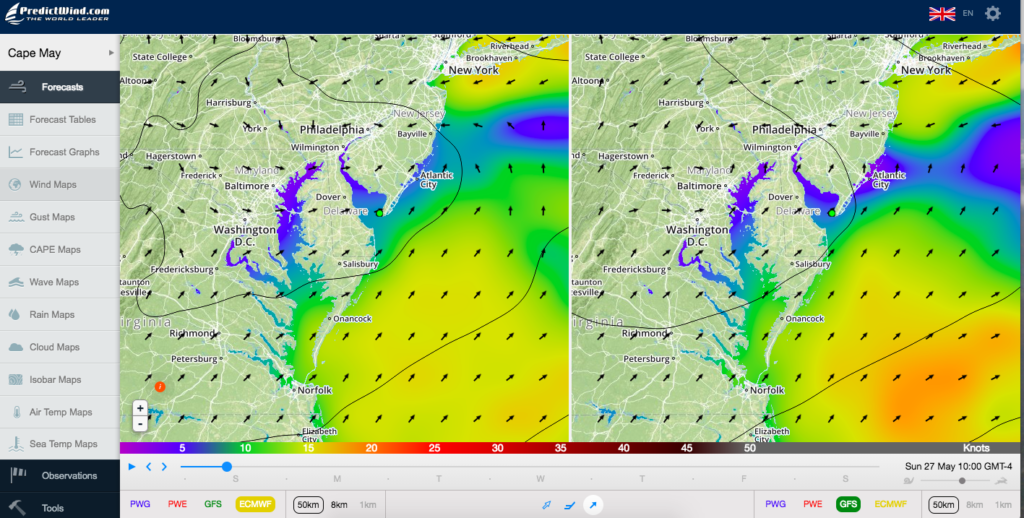
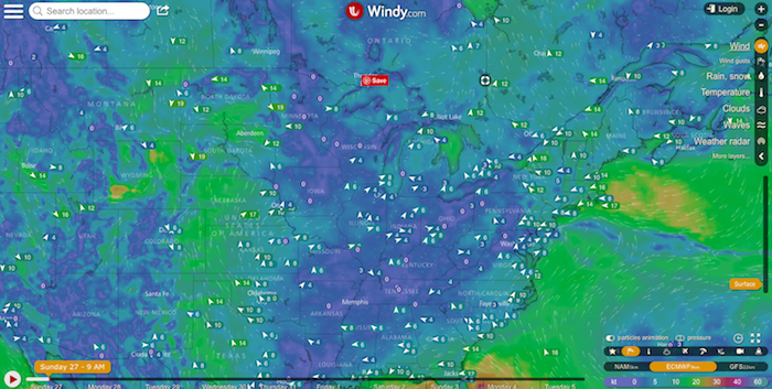
Windy.com allows you to choose which weather model you prefer, but there’s no split screen comparison feature as in PredictWind. We use both alternately. I like the Windy app better on the iPhone, but the PredictWind better on my MacBook Air screen. In both cases, we use the free version – the paid version has more bells & whistles and a longer forecast period, but a week is far enough – longer term forecasts seem to disintegrate anyway.
PredictWind has the advantage of allowing us to choose which weather models we want around the entire Loop, and the split screen (on the laptop) allows us to see the differences by sliding the slider at the bottom over the next 7 days. We use the Euro and GFS models. Zoom in on the maps to get specific area detail.
Aqua Maps and Navionics iPad, iPhone or Android apps
Aqua Maps and Navionics iPad and iPhone software both have currents information available in the app, making it easier to plan a segment of your cruise days — or even months — prior.
A free app, available for both iPhone and Google, Tides is a simple graphical app showing tides wherever and whenever you choose. It’s an easy planning tool – we’re using it right now to plan for our next Phase – either outside in the deep blue sea off New Jersey (and coming in at night) or the New Jersey ICW. Navionics has a Tides & Currents function when we’re running our Simrad chartplotter underway.
Specific Areas of Interest
Lake Okeechobee
US Army Corps of Engineers Lake Okeechobee Water Level
NWS Text Forecast for Lake Okeechobee
Chesapeake Bay
Chesapeake Smart Buoys – a handy smart phone app for both Google and iPhone showing each buoy up the Chesapeake and near real time wind & wave. Handy just before you stick your bow out into the Chesapeake to know exactly what’s out there.
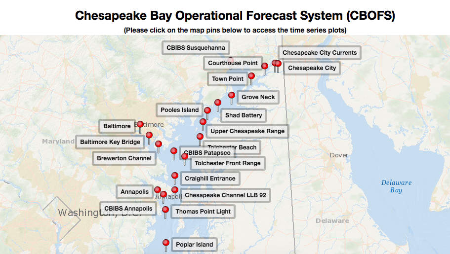
Chesapeake Bay Operational Forecast System – more in-depth buoy information from NOAA.
Tom Hale’s excellent article from Chesapeake Bay Magazine, “The Bay’s Ups and Downs” This article explains currents and tides on Chesapeake Bay and references resources to use to plan your trip.
Delaware Bay
Delaware Bay Operational Forecast System – near real time and forecast buoys in Delaware Bay.
New York/New Jersey
Currents and Waves for NY & NJ Davidson Laboratory: Urban Ocean Observatory for the NY Harbor, NJ Coastline, Hudson River etc. (Thanks to Great Loop Harbor Host Joe Pica for this information!)
Great Lakes
Great Lakes Buoys Portal – (NOTE: Overall, it seems the buoys on specific geographic area portals are also included in the NOAA National Data Buoy Center listed above.) The GLBP provides users with near real-time weather, wave, and water quality conditions observed in the Great Lakes. You can also check weather and wave forecasts, and view hazard information from the National Weather Service.
If anyone has any good weather resources for Ontario (Trent-Severn, Georgian Bay & North Channel) as well as Lake Michigan – Straits of Mackinaw down to Chicago, please let us know so we can add them to our list for this summer! Please leave a comment and share! Cheers! Jan


as I have always said, you suffer from paralysis by analysis, you would never had made it in Chris columbo’s time.
🙂 Yep! Cheers Nick! J
A perfectly timed post! It’s amazing … you were able to telepathically read my mind from a thousand miles away and determine what I was wishing you would blog about today. Thanks.
Environment Canada (they do our weather. Sort of our NOAA) has a great site.
https://weather.gc.ca/forecast/canada/index_e.html?id=ON
The link to live doppler radar for Ontario is:
https://weather.gc.ca/radar/index_e.html?id=ONT
Canadian Yacht Charters has a great set of links here:
http://www.cycnorth.com/links
Enjoy the Great Lakes! You should definitely head to the north shore of Superior. It’s hauntingly beautiful.
Thanks SO much Andrew! I’ve bookmarked these links. Cheers! J&D