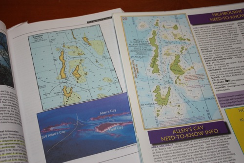
So after a lot of research, we have several choices if we want to use the best electronic charts. We already have the Explorer paper charts for the Bahamas and also the Pavilidis Cruising Guide to the Exumas. We’re comparing Allen’s Cay in the Exumas as a point of reference to see what we see on each of the charts. The featured photo to the left shows both the Explorer Charts side by side with the Exumas Cruising Guide/Pavilidis for point of reference to paper charts.
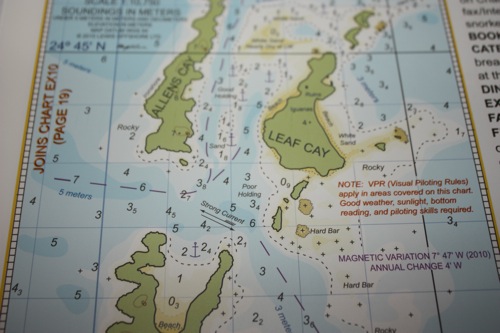
Here’s a close up of the paper Explorer Chart for Allen’s Cay. Note: I deliberately made the photos larger than usual so you can compare chart detail just as we are. That makes this post have odd gaps, but hopefully it will be helpful.
Here are our options as we see it as of December 2011:
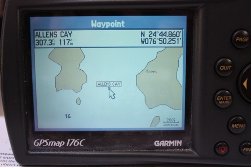
1. Buy a new DataCard for our Garmin GPSMap 176C … we already have the SE Florida DataCard which covers the Bahamas, but ours is dated 2003. For a “mere” $160, we can have the same DataCard except dated 2008. We compared the charts for a certain waypoint, Allen’s Cay in the Exumas, Bahamas and there is NO doubt that the 2008 DataCard has much more information than our 2003 version. Note that I don’t have the screenshot for the 2008 DataCard, but it’s about halfway between what you see here and the Garmin 541 screenshot shown below.
2. Buy a new Garmin GPS740S for $1,499.99 — the 7″ display and touchscreen interface are fabulous and the latest Bahamas charts (included in the SE Florida G2 card) are amazing in the amount of detail especially compared to the DataCard we’re currently using … but the pricetag is a bit extravagant to say the least. If ONLY I’d win the lottery … but I’ve heard you have to play to win … so …
3. Buy a Garmin GPS541S for $599.00. The 5″ display is still a major improvement over our little 176C and the latest G2 charts for the Bahamas are the same as on the GPS740S that we drooled over. This little jewel also has the capability to add a depthsounder fishfinder to the stern which would provide an alternative to our ages old depthsounder, just in case. The depthsounder/fishfinder was an additional $69.99. It’s difficult to see here, but the detail on the Garmin 541 is better than the Explorer paper chart above, including contour lines and information. Maybe because Garmin G2 charts use Explorer Charts as part of their database, although not exclusively as I understand it from the Explorer folks. 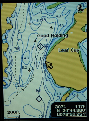
4. Update my Nobeltec Passport charts. No photo here because I don’t have Bahamas charts on my Nobeltec electronic charts. Currently we’re running Nobeltec Passport charts with a Bootcamp Windows XP split on my 5 year old MacBook Pro. But we don’t have charts for the Bahamas, only for the Western Caribbean. We can actually still buy charts for the Bahamas for this set-up, but they’re $350. And won’t work on a newer operating system … so if & when my MacBook Pro dies, we lose the Nobeltec and new charts.
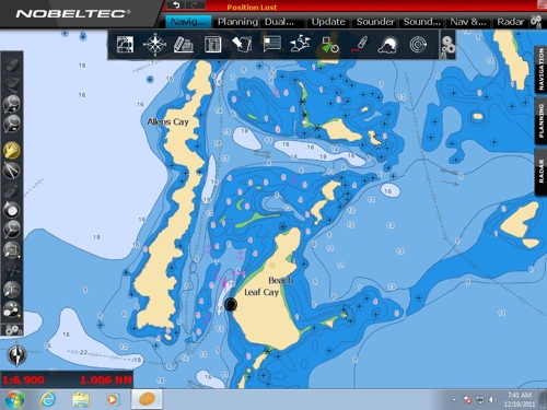
5. Update Nobeltec to Odyssey. Through March 2012, current Nobeltec owners have the option to upgrade to their new Odyssey software (from Visual Navigation Suite 8.0) for $199. This includes all the US Waters charts, but not the Bahamas and not the Caribbean. To get the Bahamas, we’d have to buy the All-Caribbean charts for another $300. So for $499, we have wonderful new charts … but no computer to run them. Hmmm.. In order to make this option work, we’d need a new Windows 7 laptop — but Dell currently has an Inspiron for $399 that would suffice to run the charts. Seems like a pricey option, but realistically WITH the new laptop, Odyssey software and the Caribbean charts, we’d have $898 invested. A lot less than $1,499 for the Garmin 740S, but the laptop is not displayable at the helm, only down on the nav desk. Of course, we still have to provide the GPS input to the laptop, but we have a hockey puck type GPS USB connection that works very well, as well as a backup USB to serial connector for the old built in GPS that also still works.
Now comes the decision making. Our charting preferences aboard Winterlude include the paper charts open on the salon table, then we’ve always had Nobeltec on the laptop on the nav desk and the Garmin GPSMap 176C at the helm. That setup took us all the way from Annapolis to Cartagena, Columbia and back to SW Florida, so obviously it worked. We like having duplicate systems – i.e. we were always running the Garmin 176 at the helm and the Nobeltec Passport charts on the laptop on the nav station — that way if one system didn’t acquire a GPS signal or had any other failure we always had the other.
If we got the Garmin 541S, we’d have it at the helm, the Explorer paper charts on the salon table and the little Garmin GPSMap 176C as a backup but it wouldn’t be running and immediately available. If we use the Garmin GPSMap 176C with it’s lack of detail at the helm, we could add the upgrade to the Nobeltec system (and have a new laptop!).
Other advantages to the Garmin 541S … we have an alternate depthsounder, it would fit in the existing bracket at the helm and use the existing 12V cigarette plug in for power. It’s not “portable” to take with us in the dinghy if we’re trying to mark a difficult entrance – such as trying to wind our way into the Marquesas in the Keys, but we still have the 176C which does operate on AA batteries.
Cost comparisons —
1. Buy the 2008 DataCard for the old Garmin GPSMap 176C $160 plus add the Nobeltec Odyssey charts/laptop $898 – Total Cost: $1058.
2. Buy the Garmin 541S with the depthsounder option and use the existing GPSMap 176C as a backup. $670 (if we bought the updated 2008 DataCard for the backup GPS, this option increases to $829).
3. Do nothing and get by with the Garmin GPSMap 176C and Explorer Paper Charts …. FREE
4. Buy the Garmin 541S with the depthsounder option and add the Nobeltec Odyssey system – this is the option that most closely resembles our current set-up, except so far beyond our charts! – $670 + $898 = $1,560 …. which is STILL comparable to buying just the standalone wonderful touchscreen Garmin 740 at $1,499 — and we’d have two complete systems.
And WHEN do we expect to win the lottery or have money fall from the sky? 🙁

MERRY CHRISTMAS WINTERLUDE! We went with option 2, the new Garmin GPS541S with the depthsounder and opted not to upgrade the 176C to the 2008. This upgrade in electronics was not in our budget, but we’re pretty happy with the 541 so far. We’ll update when we actually get to go out sailing and USE it – after Christmas. And if the money fairy does happen to drop an extra grand or two from the sky, we might consider adding the Nobeltec Odyssey, but for now, this upgrade should last us for lots of safe, happy exploring and cruising!
If you made different choices for electronics and don’t mind sharing, please leave a comment and let us know what you did! THX! Jan



I cut a huge hold in the bulkhead a year and a half ago, and mounted a Garmin 541S, and I really like it. I wish it had a large display of course, but I don’t want it to take up the whole cockpit either. The thing I really liked about it, was when my wife and I were motoring down the ICW, it gave us points of interest and eta’s to various marinas, like their auto version can find gas stations and grocery stores. It didn’t seem too nautical at first and seemed cheesy, but after a couple of days try to guess, we ended up liking the little bells and whistles. Aside from that, I too purchased a hand held raymarine 176c plotter with an intregal antenna that also has a battery, and I’m so happy with it and it’s being a mobile device. It really helped Ed and I find that bar at dusk after having sail for several days and the resturarant gave us lat and lon numbers and said that they were closing in several minutes if we wanted to get there fast, they would keep the doors open. So, yea, you gotta have both, if you can, and a couple of backups, and one to put into the Faraday sage (stove) when it’s shooting lightening bolts at cha. Its always better to know where you’re going, versus digging out your keel and seeing where you’ve been. And, it’s better to find dinner versus being lost in the keys at night with no moon nor flashlight, yee-haw.
s/v Renasci
And you have these electronic charts coupling Google Maps and original charts.
http://raynaldc.wordpress.com/carabes-vol-doiseaubird-viewing/