It’s 38 degrees outside and this tropical boat and its tropical people are freezing. So I had to do something to take my mind off of the chill. sv Island Spirit stopped at our dock a few days ago on their way to Biscayne Bay, and suggested I add Google Maps of the routes we’ve taken in the Northwest and Southwest Caribbean. (check out sv Island Spirit here for some great maps of their US East Coast travels as well as their Bahamas cruises)
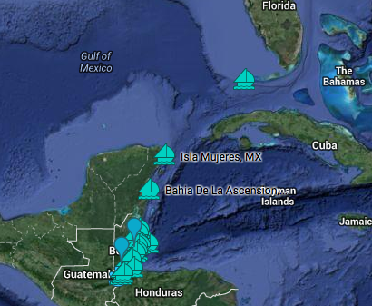
I began experimenting by putting together a Google Map of Year 1 of our Northwest Caribbean adventures – the Florida Keys to Isla Mujeres, MX, down the Yucatan Coastline to Belize, exploring Belize Year 1, and ending up the Rio Dulce, Guatemala to leave the boat for hurricane season & fly back.
 Each place we stopped has a marker. If you click the marker, you’ll find a description, a photo and a link for more information on that place on either my Sail Winterlude or Commuter Cruiser websites. I’m going to be adding more information to these route maps and making one for each of the six years we cruised the Western Caribbean. Hopefully they’ll be useful to those sailing in our wake, just as sv Island Spirit’s East Coast anchorages will be helpful for us someday when we cruise the east coast.
There are some limitations on these routes. First, they are for reference only NOT FOR NAVIGATION. There is no way to put actual lat/long waypoints so I’ve just dropped markers as close as I can to our anchoring spots. Some, as in the Rio Dulce, Google Maps won’t let me zoom in far enough to even find the bay we anchored in, and since not all places on the Rio Dulce are safe to anchor, I’ve noted that along with the name of the bay and how to find it in my note on that spot.
Other information – Winterlude is a 37′ sailboat, so if I mention time for a passage, take into account that we generally average 4.5 – 5 knots underway, less if there’s current or a headwind. Our 30 hp putt-putt engine was not meant to power us through seas, only to assist in docking & anchoring. We have a 5 1/2 foot draft.
With that said, enjoy the route! If there’s information that I should add to make it more helpful, PLEASE, leave a comment and let me know. This is my very first attempt at trying to incorporate a Google Maps for our routes and I want them to be as useful as possible.
I’ve tried to embed the actual clickable, zoomable Google Map below, but it seems to be limited by my WordPress website software, so to go to the actual map on Google, please just click this link. Then the 20 plus anchorages won’t be covered by the white listing box. 🙁 Hopefully I’ll refine this so the embedded map is resized and more easily clickable in the near future. I also noted that when I click the locations indicated by sailboats below, I get the info box, but no photo, so for how, it’s better to click the link. Here’s the link:
Cruising Dry Tortugas, Keys to Rio Dulce, Guatemala


Hi Jan,
I just found your post on sailing from Florida to Guatemala. We have our boat in San Pedro (Ambergris Caye) Belize and are planning to bring her north to Florida this spring (May). I would very much appreciate any tips you might have on going the other way! I’m expecting it to be a bit bumpy and on the nose but wondering if we’ll be able to take advantage of the Gulf Stream a bit. Look forward to hearing from you.
Doug Petty
s/v Hope
Hi Doug! Congrats on being in San Pedro – that anchorage is a bit open, but overall we loved being there! The worst thing about going north for us was waiting for the right weather. We couldn’t get out San Pedro when we were ready to go because of the easterly trades, so had to go the long way around down past Caye Caulker. But it made for a safe and easy exit, at least compared to trying to get through the rage that was San Pedro reef pass neverending. Here’s the log style post on our 2 night overnight to Isla from Caulker: Caye Caulker Belize to Isla Passage. Then we waited for a window back to Florida’s west coast. When we finally got a window – mid-May, the first 20 miles the wind was blowing then it went dead flat calm and we had to motor. Here’s the link to the last few hours of that passage: Bird Wars Passage from Isla.
Hi, I’m getting ready to head down on our Wharram 35′ catamaran. And we are debating doing key west to west end of Cuba to Belize, but I heard the straights can kick your ass , and our motor is about the same, only for calm water pushing, did you have a hard time fighting the current to get down to isla miujeras and down ? Also did you sail west and then down to get out of the current
Any info on this passage would be great! Thank you 🙂