
All week we’ve been watching a weather window that would allow us to leave the dock today and explore as far as the 10 day weather data would show. Yesterday everything fell apart. 🙁 Here’s the latest data and how we interpret it along with a couple links to earlier posts I did on how to find this information and also how to read a wind/wave chart.
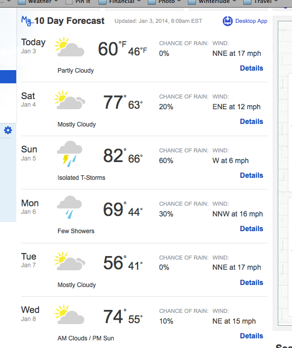
First we check the regular Weather.com 10 day forecast for the area. Two days ago it was showing even winds from an easterly component for the next 10 days. But now…
Look at Sunday, the wind goes WEST? That’s a sure indicator of a coming cold front. Usually in a cold fronts wind switches abruptly to the south, then going light west and then BAM, piping up and literally in seconds switching to the Northwest. Which can make for interesting “drag races” in some anchorages. In this case though, the wind behind the cold front we’re having right now – the NNE to ENE hasn’t even had a chance to go south before it’s going west – this cold front must be coming quickly!
After the cold front goes through, the wind will go Northeast and the temperature will often dip.
Next we listen or go check the text marine NWS forecast for the area. If you’re not familiar with how to get the text forecasts (or the wind/wave charts shown later in this post), check my earlier post “How to Get Free NOAA Weather Products”. This post includes links to NOAA weather buoys and more stuff than just the text forecasts.
As a quick reference, we also look at the WindFinder forecast.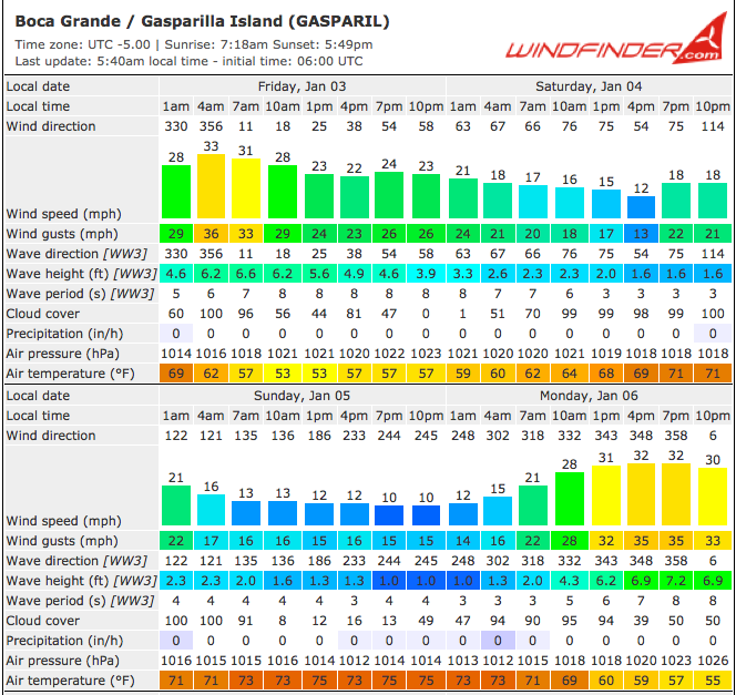
Yellow is not a good thing in the windfinder forecast because it shows times of winds above 30 … not our favorite, although in the right direction they can make for a very fast passage … nah, we’d still rather avoid yellow.
Here although you can’t see it, yellow is today and again on Monday.
So Saturday & Sunday are good. But what none of this weather data shows is that the tide in the marina won’t be high enough for us to get out of the marina until at least mid-day. So we could get out mid-day Saturday and either endure the next cold front at anchor or just stay here. Since the temperature on Tuesday is forecast to be a HIGH of 56 (and we know those of you in the frigid midwest are saying to yourselves — is she KIDDING me, complaining about a high of 56), we made the prudent decision to stay.
But David knew we would decide not to leave three days ago … not based on weather.com or WindFinder, but on the wind/wave forecast charts.
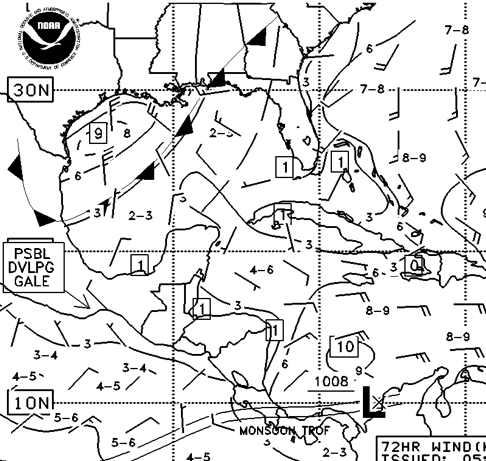
Here’s a section of the 72 hour wind/wave chart. As you can see, there’s a cold front coming off the Texas coast. And it looks fairly strong based on the wind arrows behind it. So, we have a cold front that’s stuck on top of us right now and another coming in a couple of days. OK, so we’ll sit at the dock a few days longer. If you’re not familiar with wind/wave charts, they’re important – click here for a post on “How To Read Wind/Wave Charts” or click here for “How to Get Wind/Wave Charts”
Now our window appears to be Wednesday when it warms back up and then gets into the mid-80’s for the rest of the week and weekend. Unless, of course, yet another cold front finds its way down. Until then, we have provisioning to do and maybe we’ll find some more wonderful hiking so I can take more photos! 🙂


